Posts

Team Project Showcase

Image
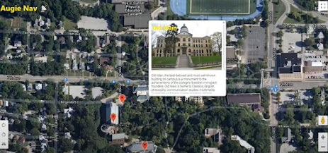
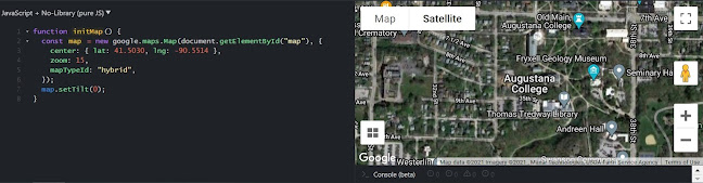
Augie Nav📡 Augie Nav is an application designed to help prospective students or even current students who might want or need to learn more about campus. It allows students to find buildings around campus, get information about the route that ACES follows, and find information about different locations throughout campus. Technologies Used React Visual Studio Code Firebase Picture storage Text information storage Google Maps API Interactive map and its functionalities Adobe Illustrator Creating icons App Architecture The extent of the map is restricted to Augustana College and the surrounding areas. Google Maps API was used to provide the functionalities of the map such as Street View, which can be accessed by dragging the small yellow person to a location.   We used Firebase for storing data about the buildings on campus, including descriptions and images. In order for the data in Firebase to be displayed properly (for example, markers), the string had to match the name of the document

Week 11

Image
 The time has finally come, the final week of work on our presentations. We had lots of work on our table, but we managed to come out with a good final product. We were able to successfully implement routes between certain buildings, a search function, as well as some other CSS things as well as custom icons for the different locations throughout campus. We were also able to clean up some of the code and iron out some errors that we were having.  This is our final transmission as we present our project this Tuesday from 9-11 to the rest of our peers. This has been a challenging project for many different reasons but overall we are happy with the outcome of our project.

Week 10

Image
 This week we were able to help students get around campus. We were able to implement a button that shows the current ACES vans route around campus. This just shows where the ACES van goes and is able to pick students up from different locations around campus. You can show the route, or hide it with the simple click of a button. We have also been able to implement more locations around campus and information about them. The red line represents the the ACES route.  We have entered the final week of this sprint. We are working on finishing up some final functionalities such as a search function, different icons for the different types of buildings, the hiding of different infoboxes when others are opened, and the ability to get directions around campus.

Week 9

Image
 This week we took a step back and assessed our progress and discussed the next steps we will be taking before the second sprint. We have also reviewed the feedback we received from classmates and professor/advisor. The basic features we intended to have on the project have been completed and we are now working on adding features to enhance the functionality of the project. Searching for buildings, suggesting routes for direction, and adding the aces route for navigation are among the features we are currently working on implementing.  The image above is how we are planning on incorporating the aces route on our map so students can look it up.

Week 8

Image
This week was special for two reasons, we were able to implement using markers which was challenging at first, however, we created components that simplified the process which also gave us a cleaner code. Amongst the components we created are the CreateMarker, InfoBox, and Markers. Our Marker components use the CreateMarker component to create the markers which holds the InfoBox component which pulls the picture, Building name, location, and other attributes from firebase displays when clicked on the Map. This week was also special because we had our first sprint. We presented the progress we have so far to the entire class and it went well and received good feedback and ideas for our project from our Teacher/Advisor and our classmates. 

Week 7: Switching to Google Mpas

Image
       This week, we decided on switching to Google Maps from Here Maps in React due to the time-consuming and confusing nature of its map implementation. The map is currently able to be displayed in hybrid mode, which shows a mix of normal and satellite views, and has the ability to be tilted at certain locations at higher zoom levels as shown below. It is also restricted to the Augustana College area and has icons turned off using styling. This API should prove much easier to work with, as well as provide features used by Google Maps. The next steps are to add markers for important locations. Source

Week 6: Map Markers and Satellite View

Image
     This week, we looked into how to add map markers for the buildings and other points of interest on campus. When clicked, they will display basic information about the location. Because a number of buildings and locations were not showing up on the basic map view, we decided that a satellite view (shown below) would be best to show what was not present on the other views. However, we are still trying to figure out how to implement this view in code. Source